On average, low-income neighborhoods have about 15% less tree cover and are 2.7 degrees Fahrenheit (1.5 degrees Celsius) hotter than high-income areas. This issue is called “shade equity,” a social and environmental justice concern focused on ensuring that shade is accessible in neighborhoods regardless of income, race, or ethnicity.
In addition to providing cooling and reducing heat-related illnesses, evidence supports the premise that tree cover in cities provides significant health benefits for people, including lower levels of air pollution, better heart function, and improved mental health. Further, trees are one of the most cost-effective, nature-based solutions that can help us cope with the climate crisis. A California study found that every $1 spent on tree planting and maintenance in urban areas returns $5.82 in benefits.
“Urban areas are at the heart of the climate crisis, because that's where 80% of our North American population lives. If we want to reduce the impact of climate change on people's lives, we must consider how our cities are going to cope with the climate crisis,” said Dr. Tanushree Biswas, carbon program director at The Nature Conservancy (TNC), a global conservation organization.
The disparity in tree cover is largely due to a series of consecutive policies that were championed by local authorities and further codified through federal actions throughout the 20th century. As population and infrastructure rapidly grew during the early 1900s, decisions were made to disinvest in neighborhoods where people of color resided. The federal government codified these decisions during the 1930s in a series of laws that gave locally authorized segregation policies the needed legal authority. The federally backed segregation policies, commonly referred to as “redlining,” divided residential neighborhoods and concentrated services, including the provision of green spaces, to wealthier and whiter neighborhoods. Communities deemed “hazardous” or “declining” were left without green spaces and other social services. In recent years, cities have been losing approximately 4 million trees each year, or 1.3% of the total urban tree stock, and American cities spend less than .3% of municipal budgets on tree planting and maintenance.
Nature is our best ally in resolving climate change.
Dr. Tanushree Biswas
Carbon program director at The Nature ConservancyPeople in urban environments are feeling the effects of this disinvestment. “We don't have a lot of trees. As a kid, I remember a lot of trees. I don't know what happened to them. They died off. People cut them down. I don't know. But it's similar to the food desert. It's a tree desert,” said Joe Ward-Wallace, co-founder of South LA Cafe and South LA Market in South Central Los Angeles. “We need trees here—it gets hot. It looks better when trees are around, and it makes people feel better.”
Numerous studies show the relationship between tree cover and local temperatures in urban areas. We know less about the logistic feasibility of increasing tree cover to mitigate urban heat and address disparities in urban green spaces. To address this gap, TNC uses data and Amazon Web Services (AWS). TNC combines and analyzes data from a variety of sources, including satellite-based measurements of tree cover, available plantable areas in cities, land surface temperatures, and socio-economic variables (like block group demographic-economic estimates), to understand the spatial feasibility of a city to support trees.
In a statewide assessment of nature-based pathways that address the climate crisis, TNC showed that urban California has up to 1.2 million acres of space available for urban afforestation and could reduce greenhouse gas emissions by planting trees on 500,000 available acres in disadvantaged and low income communities. A follow-up statewide assessment by TNC shows that California cities have space available for an additional 34 million trees. It also identifies where tree planting is immediately feasible, and predicts how much the temperature and urban heat island effects could potentially drop with the planting of new trees. According to a recent study, this would reduce the average urban land surface temperature and provide multiple co-benefits totaling $1.1 billion annually—including reduction in heat-related medical visits (more than 4,000 over 10 years) and 4.5 million metric tons of annual CO2 sequestration. In California, an annual investment of $467 million for urban afforestation using TNC's prioritization pathways will lead to $712 million of net annual benefits and serve 89% of the approximately 9 million residents in the lowest income quartiles of the state’s cities.
The geospatial data and research is even more powerful when it’s presented as a story. EsriArcGIS StoryMaps—an AWS-powered tool that combines text, video, charts, and advanced interactive geospatial visualizations—does just that. TNC uses this tool to tell a story with its data and work with partners to make it actionable for local nonprofits and government agencies across various cities. Data stored in Amazon Simple Storage Service (Amazon S3) and in Enterprise GeoDatabases like Amazon Aurora can be analyzed and brought into StoryMaps to show how a city changes over time. Using advanced Esri ArcGIS Server and Image Server tools running on Amazon Elastic Compute Cloud (Amazon EC2) makes it fast and efficient to perform analysis and integrate the data in StoryMaps. In addition to displaying the geospatial data, StoryMaps organizes and styles the data to emphasize points in real-time complex illustrations.
Once the data is translated into a StoryMap, TNC uses it as a tool to communicate with legislatures, policymakers, and stakeholders. For example, the entire Natural Climate Solutions (NCS) pathway report for California is available as a StoryMap. It provides easy access to maps and data, and contributes to an interactive user interface that shows possible opportunities for a multisector NCS intervention in the landscape. In addition, TNC can show opportunities for urban afforestation along with how it lines up with other climate mitigation pathways. This further assists conversations with policymakers, state agencies, and stakeholders.
Following the completion of the NCS pathway report, TNC used the StoryMap to design a series of regional roundtable discussions with local and grassroots-level organizations across California to promote a bottom-up approach to understanding the barriers and challenges of implementing nature-based solutions in the region. They gathered folks from the urban, forest, and natural working land sectors to talk to each other, and identify barriers and solutions to using nature as a climate change solution. TNC also did a roadshow with its StoryMap, with state agencies, showing the potential opportunity of using nature across California to mitigate climate change.
“Nature is our best ally in resolving climate change,” said Biswas. “StoryMaps helps us build the bridge to communicate science into action and take successful examples implemented locally to scale.”
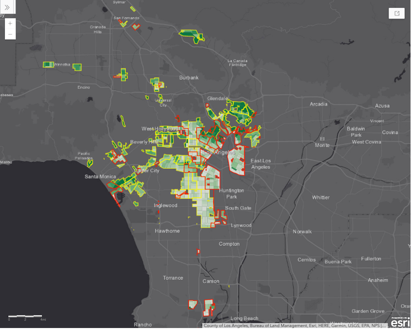
 The map shows the tree canopy coverage at the census tract level as it relates to the redlined areas of Los Angeles. The places outlined in yellow and red represent areas that were deemed by the government as “definitely declining” and “hazardous” communities, respectively. These regions experienced extreme divestment, which meant that there was a lack of financial support from governments and financial institutions to invest in the well-being of these communities. As a result, these communities have a lack of tree canopy coverage, as represented by the lighter color scheme.
The map shows the tree canopy coverage at the census tract level as it relates to the redlined areas of Los Angeles.This work is happening in real time in Los Angeles. The city has a tree equity goal as part of the Green New Deal directive led by Mayor Eric Garcetti. One of the key principles is to deliver environmental justice and equity by increasing the tree canopy by 50% in the areas of greatest need by 2028.
To help reach this goal, City Plants, an organization based in Los Angeles, collaborates with TNC scientists to translate science into action and achieve outcomes on the ground. Together, they aim to grow a greener future by engaging Angelenos to plant and care for trees throughout the city. The organization uses TNC’s science, research, tools, AWS technology, and actionable StoryMaps to help carry out an equitable tree-planting strategy in Los Angeles.
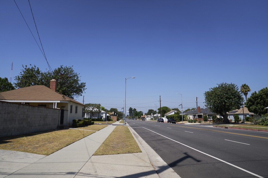
 This photo captures the clear lack of shade and tree cover on a downtown Los Angeles street.
“I really like to see how we can use the best available science and information to help inform the decisions on the ground. City Plants is by no means alone in that journey, but we get to take the work of tree planting prioritization that TNC is helping to define through mapping and other innovative tools, and apply it directly here in Los Angeles,” said Rachel O’Leary, executive director at City Plants. “When we’re faced with huge, ominous, harrowing, scary ideas and issues like climate change, I see tree planting as a vehicle to overcome a lot of that anxiety and grow solutions together.”
AWS Cloud services have been key to allowing TNC to store data, conduct research, and create actionable visualizations to make progress on its mission. Identifying space for additional trees is only a beginning step. While knowing where we can strategically increase tree cover and reduce shade inequity is an important step, much larger and sustainable funding mechanisms are needed. We must also ensure the maintenance of urban trees and scale efforts beyond individual cities. “The globe has to reduce its temperature, which means we have to work on something big. We have to really work together,” Biswas said. “We have to think, ‘What are the lessons that our partners have learned here that can be applied to other cities?’ That’s the power of cloud computing—the exchange of human knowledge.”
AWS is proud to support innovation and nature-preserving organizations like TNC and City Plants, and will keep working to help future generations enjoy a tree-rich and sustainable environment.
The AWS original four-part Climate Next documentary series features stories about people and communities around the world driving innovation and creating scalable solutions to address climate change.
Trending news and stories


